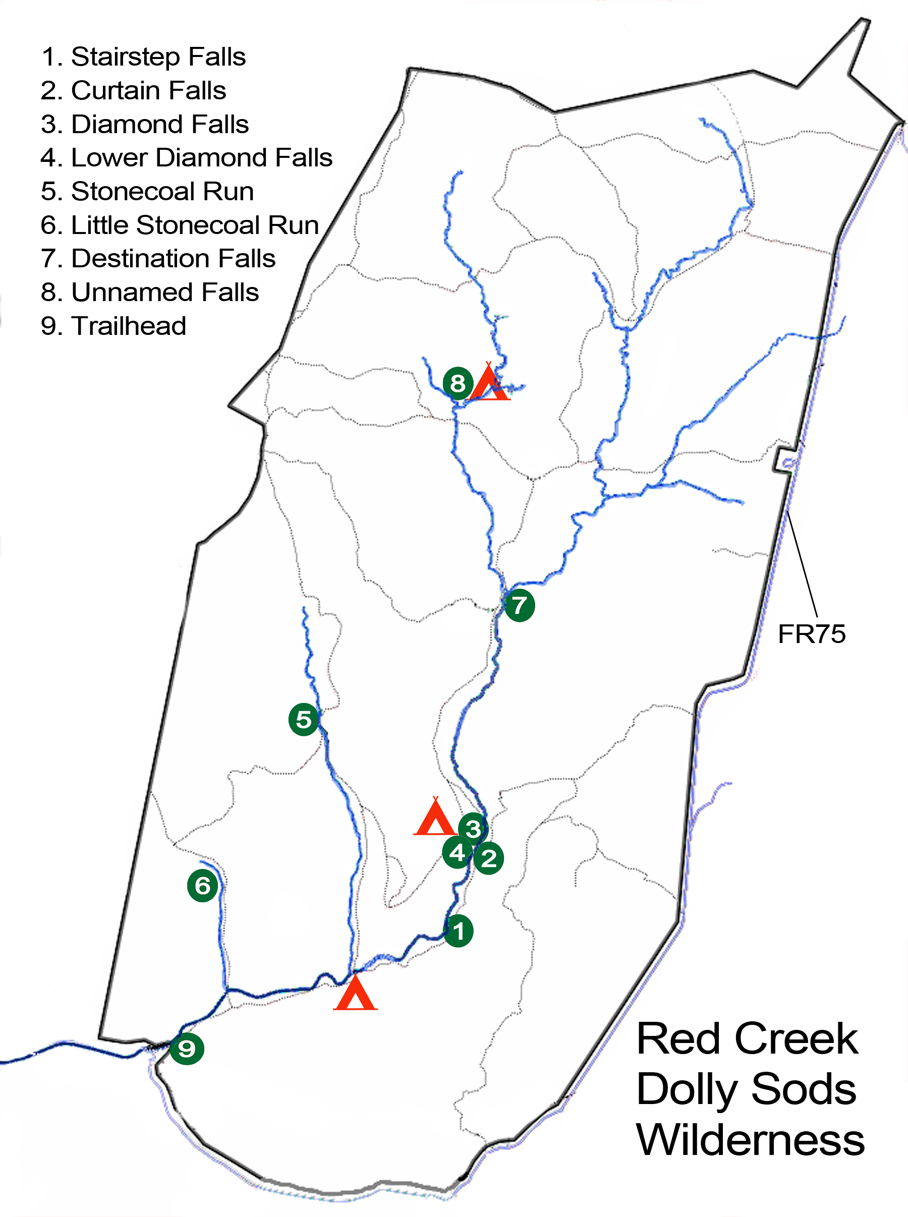
Red Creek Trailhead
Dolly Sods Wilderness
38.972561, -79.398251
38°58'21.2"N 79°23'53.7"W
From Davis, follow WV 32 south past the Canaan Valley Resort and turn a sharp left on Laneville Rd (CR 45/4). Follow Laneville Rd. for 5.8 miles and just after you cross over the bridge on Red Creek, there will be a parking area with a cabin. This is the trailhead parking.
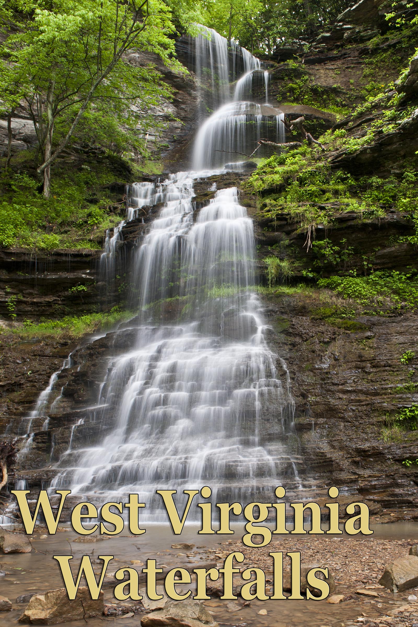
Dolly Sods has some very beautiful waterfalls. Anne Johnson has photographed and hiked the Red Creek and offers her images and directions. Images and trail descriptions courtesy of Anne Johnson. I think she lives at Dolly Sods. She definitely loves the place. Anne's website.
- I have created a google topo map of the falls locations. It does not profess to be 100% accurate, and in several cases may be off base, but will give you a rough idea of the terrain and locations.
- Here's a link to the U.S. Forest Service trail map for Dolly Sods which includes the Red Creek area trails. (PDF Version).
Directions: (From Forest Service Website)
From Petersburg follow WV 28/55 south to Jordan Run Road. Turn right and go 1 mile to Forest Road 19. Turn left and follow FR 19 six miles to the Dolly Sods Scenic Area. The wilderness is directly ahead of you at the intersection with FR 75. Turn right for Wildlife and Fisher Spring trailheads; turn left for Rohrbaugh and Red Creek trailheads.
From Canaan Valley: follow WV 32 south to the Laneville Road (WV 45). Turn left and go approximately 6 miles to the Red Creek Bridge, where the road changes from pavement to gravel and is now Forest Road 19. Red Creek trailhead is on the left behind the Laneville wildlife management cabin. Continue on FR 19 to get to Rohrbaugh trailhead and FR 75.
Please be aware that there are no blazes or markers on the Red Creek Trail. You will find some cairns from time to time to indicate a juncture, but nothing that specifically says where to go. Download the PDF map, study it, maybe print a copy and calculate some GPS coordinates from a Google map, or similar, to help you get there. Basically, the trail follows Red Creek's eastern shore from the Laneville cabin, but does wander away from the water quite a bit in spots. Once you pass a few campsites in the early goings (this is where to look for cairns as the trail is less obvious) you will enter some thick areas before the trail becomes more obvious. It climbs up and away from the creek for awhile, before dropping back in at Curtain Falls and the creek crossings near Fisher Spring Run.
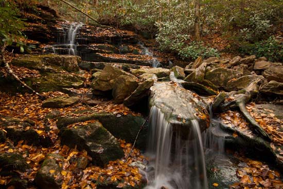
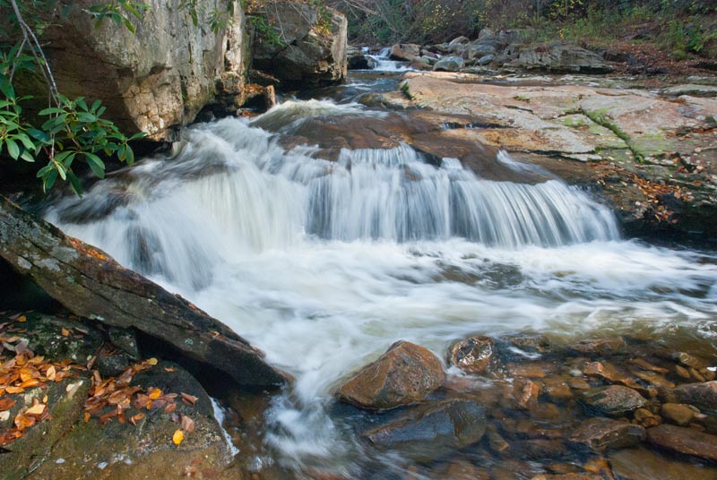
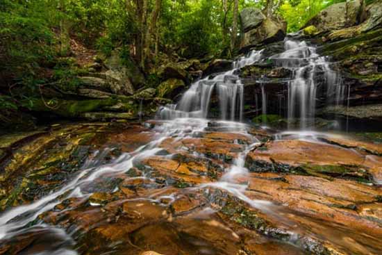
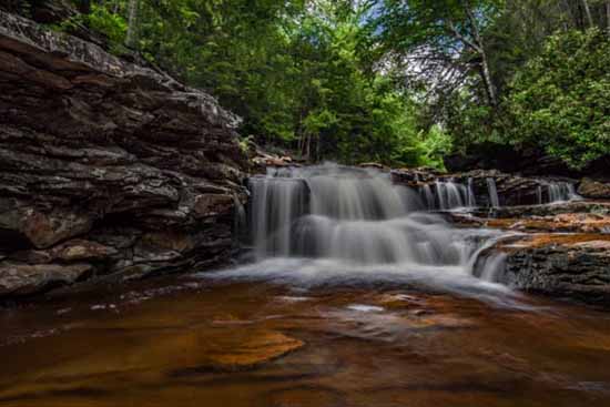
Stairstep Falls
38.98149, -79.36566
38°58'53.4"N 79°21'56.4"W
This is the first fall on this trail. It is a small but interesting place fed by a small drainage. You can't miss it. You have to walk right over it. Good place to have a short rest and snap a few shots. Begin at the Laneville Cabin trailhead and follow the Red Creek Trail for approximately 2 miles. Waterfall is by the trail.
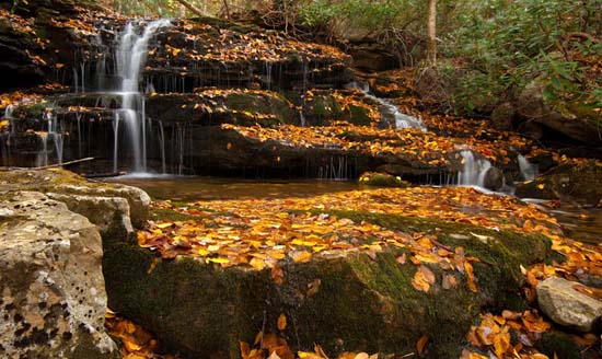
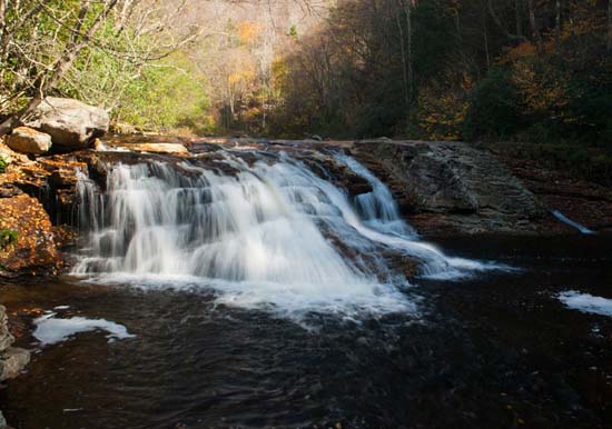
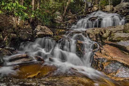
Curtain Falls
38.98459, -79.35901
38°59'04.5"N 79°21'32.4"W
Approximately 2 1/4 miles from the trailhead. It is approximately 1/4 mile past Stairstep Falls and is by the trail. The trail goes just above the top of this fall. Begin at the Laneville Cabin trailhead and follow the Red Creek Trail for approximately 2 1/4 miles.
Once you cross over, the trail bends to allow for the hollow made by this fall. You will see places to enter the creek here. There are several good angles here. Afterward, see if you can cross over Red Creek and visit the next fall. Diamond Falls. It is just down stream from where this falls' runoff feeds Red Creek.
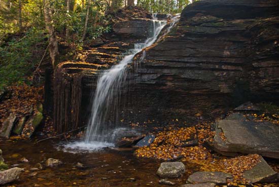
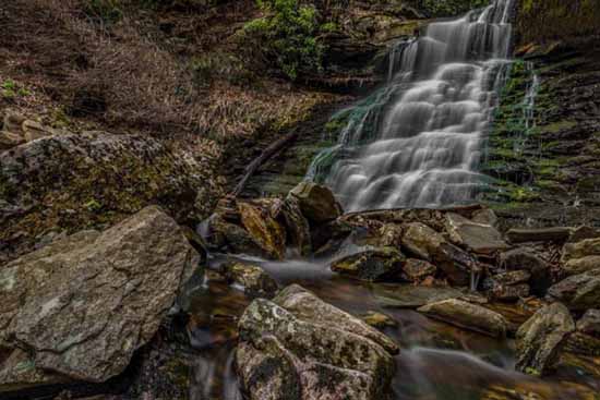
Diamond Falls
38.98469, -79.36102
38°59'04.9"N 79°21'39.7"W
Begin at the Laneville Cabin trailhead and hike Red Creek trail, passing the Big Stonecoal junction. When Red Creek trail starts up hill, go left off the trail and toward Red Creek. Cross the creek and follow an overgrown railroad grade for approximately 1/2 mile. Diamond Falls is off trail on the right. Another approach is from Curtain Falls. If the river is not too high, you can cross just upstream from the bottom of Curtain Falls where it empties into Red Creek. It's pretty shallow here and there are some rocks to hop across on as well. The falls is just downstream from here.
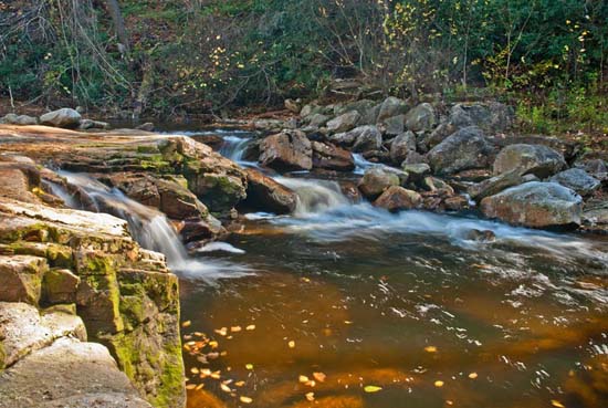
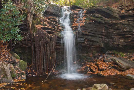
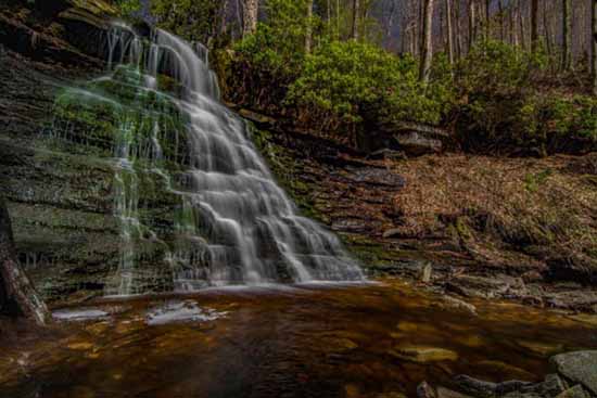
On a recent trip, we encountered a fall below Diamond Falls. At about 100 yards downstream, you will find another small but beautiful falls that had gone previously unnamed, to my knowledge, as well as others. Anne Johnson, a regular Red Creek trekker, suggested that I give it a name. Lower Diamond Falls came to mind immediately, but I dismissed it out of hand, and Anne agreed with me that Rock Face Falls was a good name, so here is Rock Face Falls. You will also find an excellent camping site right here beside Red Creek. Nice and flat with a fire pit.
Big Stonecoal Run
38.9966, -79.37257
38°59'47.8"N 79°22'21.3"W
Begin at Laneville Cabin trailhead and hike 1 1/2 miles up Red Creek to the Big Stonecoal junction, and cross Red Creek. Take Big Stonecoal trail 1 1/2 miles up hill. Waterfall is trailsie. Rough hike.
Little Stonecoal Run
38.98583, -79.38967
38°59'09.0"N 79°23'22.8"W
Begin at Laneville Cabin trailhead and hike 1/2 mile up Red Creek to the Little Stonecoal junction. Take Little Stonecoal Trail, crossing Red Creek in about 200 yards. Continue up Little Stonecoal Trail for less than a mile, and waterfall will be on the left of the trail.
Destination Falls
38.995371, -79.355142
38°59'43.3"N 79°21'18.5"W
Take Fisher Spring trailhead, follow the trail approximately 2 miles until you are within sight of Red Creek. Go off trail to the right and cross Red Creek, then bushwhack up the creek 1/4 mile.
Unknown Falls
39.01895, -79.35278
39°01'08.2"N 79°21'10.0"W
I saw this falls on a kayakers video. Have not been there myself. There's also a nice campsite there and the area can be reached from the escarpment on several different trails. Use the GPS and figure your own route.
Download the PDF map from the USFS website or from West Virginia Waterfalls website. Study it and take it with you. There are no trail blazes or signs on Red Creek. There are cairns, but no telling if they will be there when you are looking for them.