Header

Toggle Navigation
  • Home
    • ALPHA LIST
    • Best Waterfalls in West Virginia
    • Cool Places
    • Contact
    • WVW Map
    • West Virginia Waterfall Trail
  • Metro
    • Campbell Creek
    • Coonskin Creek Falls
    • Hemlock Falls
    • Howells Mill
    • Pinch Creek
    • Upper Falls
    • Weberwood
  • Hatfield/McCoy
    • Alpoca Falls
    • Drawdy Falls
    • Long Branch Falls
    • Rockhouse
    • Turkey Gap Fill Up
    • Twin Falls State Park
    • White Oak Creek Falls
  • Mid-Ohio
    • Bee Tree Run
    • Peter Cave
    • St. Marys
    • The Jug
  • New River/Greenbrier
    • Amigo
    • Babcock State Park
    • Beckley South
      • Beckley Mill
      • Blue Hole
      • Bluestone State Park
      • Brush Creek Falls
        • White Oak Falls
      • Camp Creek State Park
      • Little Beaver State Park
      • Little Whitestick Creek
      • Wolf Creek Falls US 19
    • Billy Redden Falls
    • Camp Branch
    • Carper Falls
    • Cooper's Mill
    • Dowdy Creek Falls
    • Fayetteville Area
      • Beckwith Rd.
      • Butcher Branch
      • Coal Run
      • Craig Branch
      • Fern Creek Falls
      • Kaymoor Falls
      • Keeney Creek
      • Marr Branch
      • Short Creek Falls
      • Wolf Creek Falls
    • Gauley River NRA
      • Laurel Falls
      • Ramsey Branch
      • Gauley 1
      • Gauley2
      • Gauley3
      • Confluence Falls
      • Mason Branch
      • Bucklick Branch
      • Peters Creek
    • Glen Ferris Area
      • Boonesboro Road
      • Cathedral Falls
      • Charleton Heights Falls
      • Falls Creek
      • Hidden Falls
      • InBetween Falls
      • Kanawha Falls
      • Riggs Branch
    • Glade Creek
      • Kates Falls
    • Hawks Nest
      • Turkey Creek
    • Hemlock Hollow
    • Honey Branch
    • Little Fat Creek
    • Little Wolf Creek
    • Meadow River Access
    • Oak Hill Area
      • Arbuckle Creek
      • Minden Rd. Falls
      • Meadow Fork
      • Dunloup Creek
    • Propps Ridge Falls
    • Peachtree Falls
    • Pipestem
      • Indian Branch Falls
    • Rhoda Ann Falls
    • Westerly Falls
    • Sandstone Area
      • Big Branch
      • Claypool Falls
      • Fall Branch
      • Kates Branch
      • Lick Creek Falls
      • Madam Creek Falls
      • Mill Branch
      • Outfitters Falls
      • Sandstone Falls
    • Spruce Run
    • War Ridge
    • Waterfall Park
  • Mountaineer
    • Big Cove Run Falls
    • Big Run (Preston Co.)
    • Bruceton Mills
    • Cobun Creek
    • Deckers Creek
    • Fortney Mills
    • Hustead Fork
    • Matador
    • Moats Falls
    • Muddy Creek
    • Nuzum Run
    • Pell Rd. Falls
    • Pringle Run
    • Quarry Run Falls
    • Saltlick Creek Falls
    • Scott Run
    • Shower Bath Falls
    • Sovern Falls
    • Stoney Run
    • Swallow Falls
    • Tom's Run
    • Tunnelton
    • Valley Falls
    • Wonder Falls
    • Wolf Creek Falls (US 50)
  • Mountain Lakes
    • Brushy Meadow Falls
    • Buffalo Creek
    • Burnsville Waterfall
    • Cottle Falls
    • Cranberry Wilderness
    • Elk River
    • Fall Run
    • Flatwoods Run
    • Fiddlers Mill
    • Falls Mill
    • Georges Falls
    • Holly River State Park
    • Hominy Falls
    • Leatherwood Creek
    • Lincamp Branch
    • McCoy/Boggs Falls
    • Panther Creek (Nettie, W.V.)
    • Rudolph Falls
    • Summersville Lake
    • Whitaker Falls
    • Wildcat Falls
    • Windy Run
  • Potomac
    • Albert Falls
    • Big Run (Tucker Co.)
    • Blackwater Falls State Park
      • Blackwater Falls
      • Falls Run Falls
      • Pendleton Run
      • Shays Run
    • Brushy Fork
    • Brushy Run
    • Colleen Falls
    • Cool Spring Park
    • Douglas Falls
    • Dry Run
    • Elklick Run
    • Edray
    • Falls Gap
    • Falls of Hills Creek
    • Flatrock Run
    • Hambleton Spill
    • High Falls of Cheat
    • Jordan Run
    • Junior
    • Kennedy Falls
    • Maxwell Run
    • Mill Creek Falls (Kumbrabow)
    • Mill Run
    • Red Creek
    • Red Run
    • Red Run - Shavers
    • Seneca Creek
    • Spring Run
  • Panhandles
    • Falling Waters
    • Oglebay Park Falls
    • Tomlinson Run State Park
  • Photos

CLICK THE BOOK TO GET THE BOOK!


Click here to get the book!PrintCoverwebcopy

Maps

  • W.V. Waterfall Map
  • W.V. Watershed Map
  • West Virginia Trail Inventory
  • Babcock State Park
  • Blackwater Falls State Park
  • Bluestone State Park
  • Cranberry Wilderness Trail Map
    • Cranberry Wilderness Trail Info
  • Deckers Creek & Rail Trials of N. Central WV
  • Dolly Sods
  • Hawks Nest State Park
  • Holly River State Park
  • Kumbrabow State Forest
  • Kanawha State Forest
  • New River Watershed
  • New River Gorge Trails
  • Oglebay Trails - Unpaved
  • Oglebay Trails - Paved
  • Otter Creek Wilderness
  • Pocahontas County Map
  • Seneca Creek
  • Twin Falls State Park
  • Valley Falls State Park
  • TomlinsonRunStateParkMap

Waterfall Websites

  • West Virginia Waterfalls
  • West Virginia Waterfalls Group
  • North Carolina Waterfalls
  • North Carolina Waterfalls Group
  • Tennessee Landforms Site
  • Waterfalls of Tennessee Group
  • Waterfalls of Georgia Website
  • https://www.virginia.org/waterfalls
  • Ohio Waterfalls
  • Kentucky Waterfalls
  • Waterfall Junkies
  • Waterfalls of KY TN WV NC AL VA OH PA IN
  • Kentucky Waterfalls, Arches and Landscapes
  • Waterfalls of the Northeastern United States
  • World Waterfall Database

Sandstone Falls

Category: New/Greenbriar
Published: 24 March 2020
Hits: 4432

Sandstone01

37°45'34.5"N 80°54'18.2"W

37.759576, -80.905056

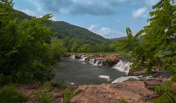
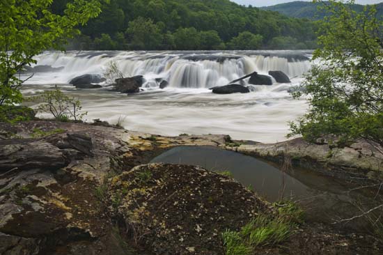
Directions to Sandstone Falls Parking area.  From I-64 take exit 139.  At the end of the exit turn left on WV 20 and drive for about 11 miles into the town of Hinton taking a left on 2nd Ave. and then an immediate right and go across the bridge.  On the other side of the bridge turn right.  (Madam Creek is just here on your left).  Drive for another 8.3 miles after crossing the bridge to the Sanstone parking lot.

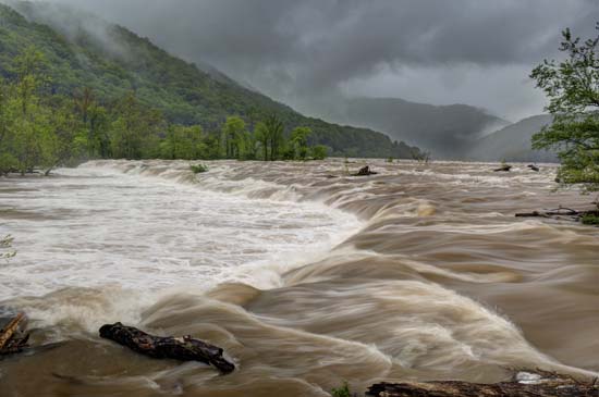
Once here, there are restroom and picnic facilities.  Walk out onto the boardwalk to get out into the river and in the thick of it all.  Even in low water, you will get wet if you want to get out on the rocks for the upclose and personal experience of Sandstone Falls.  Go to the end of the boardwalk to the overlook, then look up river to plot a course to get out on the rocks.  If the water is high, you can still do this without much trouble, but you have to be careful and bring your hip waders or just get wet.  Footing in the backwaters is iffy even at low water, but with the rush of high water, it makes it more difficult.

Anyway, you can get right out where ther falls are crashing and walk along the precipice and photograph till your hearts content.  You can spend a whole day here easily.

Sandstone05

Sandstone14

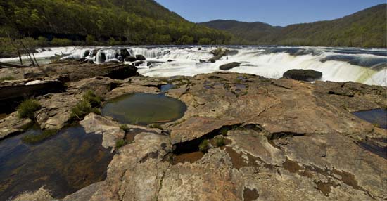
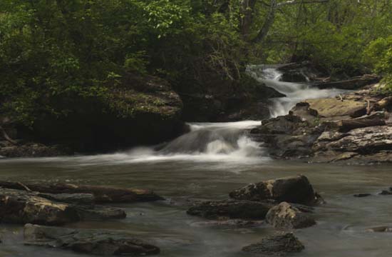
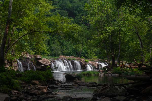
You'll find isolation shots all over the place but this is one of my favorite spots.  Wish I could tell you exactly where it is, but not sure if I can describe.  You'll see it if you venture in.

Sandstone11

Sandstone07

Sandstone018

Sandstone08

Disclaimer

Waterfalls can be dangerous. Neither Rick Hartigan or wvwaterfalls.com  give permission to any person to rely on the information on this web site for their safety. Directions, tips and guidance on this web site are provided for general information only. No guarantee of safety or lawfulness is implied.  Always check ownership and get permission before entering a property.

Site Search


Back to Top

© 2023 West Virginia Waterfalls